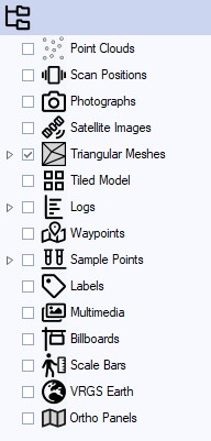
Data Tree
The Data Tree contains all data imported or created in a VRGS project. The data types and categories are described below.

| Type | Symbol | Description |
|---|---|---|
Point Cloud | Data category for all point cloud data imported or created in the VRGS project. | |
Photographs | Data category for all imported photographs. | |
Satellite Imagery | Data category for all imported satellite imagery in the VRGS project. | |
Triangulated Mesh | Data category for all triangulated surface mesh data imported or created in the VRGS project. | |
Tiled Models | Data category for tiled models imported into VRGS. Supports SLPK and GeoTiff. | |
Logs | Data category for all logs (e.g., sedimentary log, geophysical logs) imported created in the VRGS project. | |
Waypoints | Data category for all waypoints imported or created in the VRGS project. | |
Samples | Data category for sample information added to the VRGS project. | |
Labels | Data category for all labels attributed to the outcrop data in the VRGS project. | |
Scale Bar | Data category for all scale bars added to the VRGS project. | |
Ortho Panel | Data category for all orthopanels created in the VRGS project. | |
VRGS Earth | Data category for all imported global elevation datasets. |